How Ukrainian Startups Forged a New Era of GPS-Free Drone Navigation
The relentless electronic warfare (EW) environment of the Ukraine conflict has rendered a cornerstone of modern technology—GPS navigation—increasingly obsolete. Russian jamming and spoofing operations have created vast “GPS-denied” zones, crippling drones reliant on satellite signals and forcing operators to navigate by landmarks like “weird-looking buildings” . In this crucible of necessity, Ukrainian startups have engineered a revolution, developing resilient, GPS-free navigation systems that are reshaping the future of drone warfare and offering a blueprint for defense innovation globally.
The Crucible: Why GPS Failed on the Ukrainian Battlefield
The full-scale invasion unleashed an unprecedented electronic warfare onslaught. Russian systems blanket frontlines with powerful interference, disrupting or falsifying GPS signals:
- Ubiquitous Jamming: Dimko Zhluktenko of Ukraine’s Unmanned Systems Forces starkly noted, “At the front line, there is literally no GPS… the drone thinks he’s in one position while, in fact, he’s in completely another” .
- Operational Paralysis: Missions failed as drones drifted off course, strike accuracy plummeted, and expensive Western munitions relying on GPS guidance proved vulnerable .
- Human Limitations: Operators resorted to visually matching drone camera feeds with satellite maps using landmarks—a painstaking, error-prone process, especially in Eastern Ukraine’s featureless terrain .
This critical vulnerability became an urgent catalyst. Traditional defense procurement cycles, often spanning years, were irrelevant. Ukraine needed solutions developed, tested, and deployed in weeks or months, not years.
The Architects of Resilience: Key Startups & Their Navigation Breakthroughs
Ukrainian engineers, often pivoting from civilian backgrounds, founded agile startups to tackle the GPS bottleneck. Their solutions diverge radically from satellite dependence:
1. Alternative Signal Navigation: Time-of-Flight Systems
- Sine.Engineering: Founded in 2022 by Andriy Chulyk (formerly in the standing desk business), this Lviv-based company pioneered a modular time-of-flight (ToF) system inspired by pre-GPS aviation principles .
- How It Works: A small communication module on the drone exchanges signals with a ground station and two stationary beacons with known coordinates. By precisely measuring the time it takes signals to travel between these points, the drone’s software calculates its exact location via triangulation .
- Advantages: Immune to satellite jamming; operates on multiple bandwidths to evade frequency-specific jamming; relatively low-cost and scalable; already deployed on thousands of Ukrainian ISR and FPV drones .
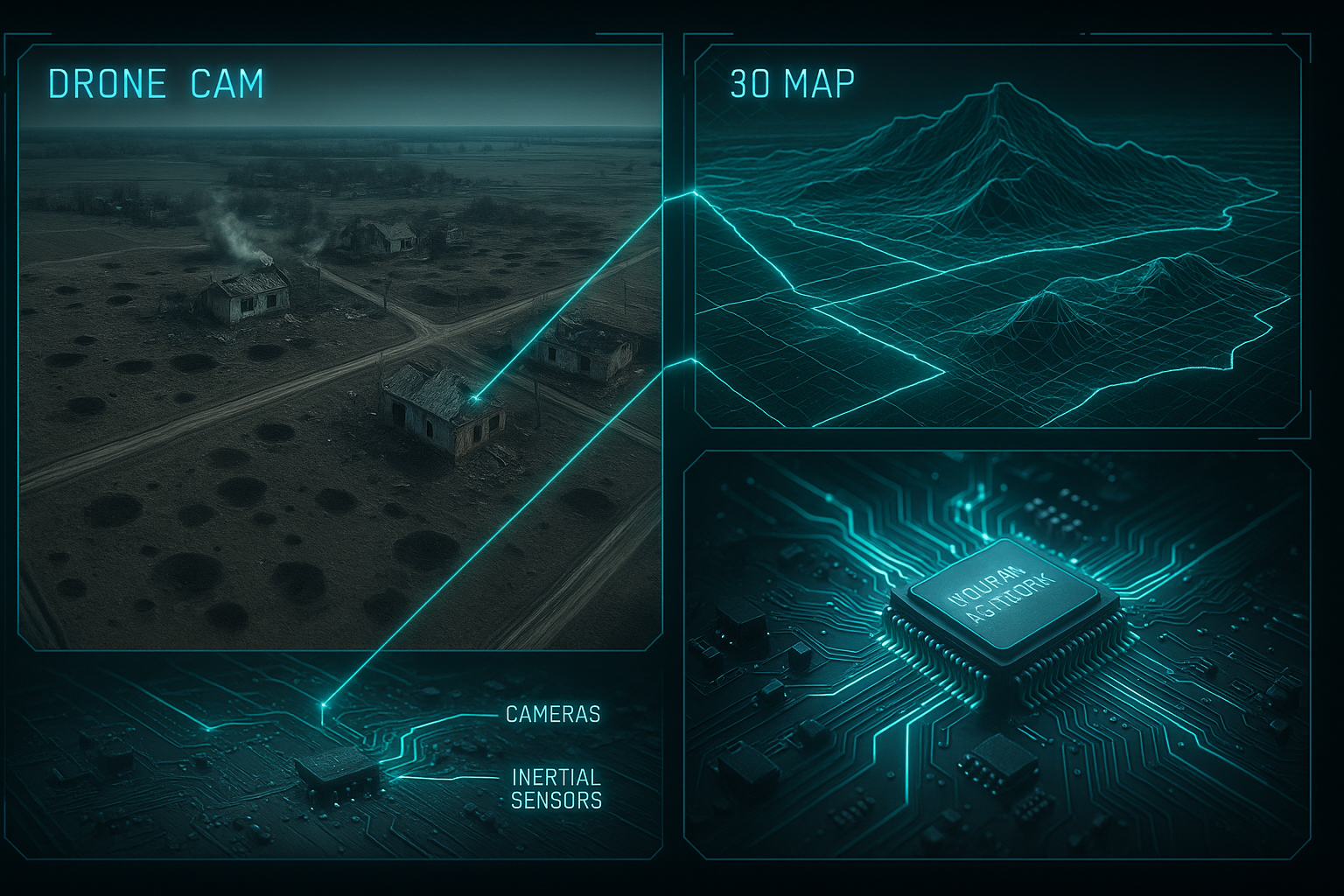
2. Visual-Inertial Navigation: Seeing Like a Bird (with AI)
- Blue Arrow (Brave1 Cluster): Developed an autonomous visual navigation system making drones “impossible to knock off course” .
- How It Works: The drone uses onboard cameras to capture the landscape below. AI-powered software compares this live video feed in real-time against pre-loaded high-resolution 3D terrain maps (generated from satellite imagery). Simultaneously, inertial sensors (accelerometers, gyroscopes) track speed, direction, and movement, calculating the drone’s position (azimuth) autonomously. This “map-matching” occurs continuously .
- Advantages: Complete independence from external signals; demonstrated ability to navigate complex combat routes with GPS manually disabled; transforms the operator role to high-level supervision/confirmation .
- Vermeer (US/Ukraine Collaboration): Provides a compact module integrating day/night cameras, computational units, and preloaded 3D maps for inertial-visual navigation .
3. Fiber-Optic Tethering: The Physical Link
- Shovkopryad (“Silkworm”): Developed by Ukraine’s Unmanned Systems Forces, this is a universal fiber-optic module for air, ground, and sea drones .
- How It Works: A physical fiber-optic cable unspools behind the drone, maintaining a direct, secure data link with the operator.
- Advantages: Immune to all forms of radio jamming; maintains full control and video feed at ranges exceeding 20km; Ukrainian operators report no performance difference vs. radio-controlled drones .
Table 1: GPS-Free Navigation Approaches in Ukrainian Drones
| Technology | Key Players | Core Mechanism | Advantages | Deployment Stage |
|---|---|---|---|---|
| Time-of-Flight (ToF) | Sine.Engineering | Signal timing between drone/ground/beacons | Jamming-resistant, low-cost, scalable | Widespread (ISR/FPV) |
| Visual-Inertial + AI | Blue Arrow, Vermeer | Camera + terrain map matching + inertial sensors | Full autonomy, immune to EW, enables complex routes | Field deployment & scaling |
| Fiber-Optic Tether | Shovkopryad (Ukraine) | Physical cable link | 100% jam-proof, long range (20km+) | Field testing & integration |
The Enabling Force: Artificial Intelligence and Sensor Fusion
These navigation systems are not merely mechanical; they are deeply intelligent. AI, particularly machine vision and neural networks, acts as the central nervous system:
- Computer Vision: Algorithms process live video feeds, identifying landmarks, terrain features, and even targets with increasing accuracy, enabling systems like Blue Arrow’s map-matching .
- Sensor Fusion: AI critically integrates data from multiple sources – visual cameras, inertial measurement units (IMUs), LiDAR (e.g., SmartPilot on the “mother drone” ), altimeters, and sometimes radar. This creates a robust, multi-layered understanding of position and environment far exceeding any single sensor’s capability .
- Autonomous Decision-Making: AI allows drones to recalculate routes, avoid obstacles, and even proceed with core mission objectives (like striking a pre-designated target type) if contact with the operator is lost . KrattWorks’ Ghost Dragon drone, for instance, uses neural networks for autonomous flight and reorientation without GPS .
The Ukrainian Edge: Why Startups Succeeded Where Giants Stumbled
Several factors unique to Ukraine’s wartime reality accelerated this innovation:
- 24-Hour Battlefield Feedback Loop: As Sine.Engineering’s Chulyk highlights, proximity to the front allows direct input from operators. Products are tested under live fire daily, and iterations happen in weeks, not years .
- Bypassing Bureaucracy: Lightly regulated defense tech sectors and initiatives like the Brave1 cluster rapidly connect startups, the military, and funding, accelerating R&D and deployment (e.g., Blue Arrow’s development under Brave1) .
- Cost-Effectiveness Focus: Startups prioritized affordable, scalable solutions compatible with attritable platforms like FPV drones. Sine.Engineering and Huless focused on keeping costs low while adding autonomy .
- Agile “Garage Innovation”: Small teams unburdened by legacy systems pivoted quickly. Auterion shifted from grocery delivery drones to battlefield terminal guidance software in response to Ukraine’s needs .
Table 2: Advantages of Ukraine’s Startup-Driven Development Model
| Factor | Traditional Defense Model | Ukrainian Startup Model | Battlefield Impact |
|---|---|---|---|
| Development Cycle | Years | Weeks/Months | Rapid adaptation to evolving EW threats |
| Feedback Mechanism | Formal testing, simulations | Direct 24h operator input | Solutions refined for real-world, harsh conditions |
| Cost Structure | High overhead, expensive systems | Low-cost, scalable modules | Enables mass deployment on attritable drones |
| Regulatory Burden | Heavy bureaucracy | Light-touch, agile (e.g., Brave1) | Faster R&D, testing, and fielding |
| Operator Focus | Complex systems requiring specialists | Simplified interfaces, automation | Reduces training time, minimizes human error |
Transforming the Battlefield: Tactical and Strategic Impact
The deployment of GPS-free drones is altering the dynamics of the conflict:
- Sustained Precision in EW Environments: Operations like “Spider’s Web” (damaging Russian bomber fleets) demonstrated the ability to execute complex, coordinated strikes deep behind enemy lines despite pervasive jamming, relying on systems like Sine.Engineering’s tech .
- Rise of Autonomous & Swarm Capabilities: GPS-free navigation is foundational for drone swarms. Sine.Engineering’s “Pasika” and Blue Arrow’s fully autonomous missions represent the next step: groups of drones coordinating attacks with minimal operator input .
- The “Mother Drone” Concept: AI-powered carriers like the one debuted by Ukraine (range: 300km, cost per mission: ~$10,000) use visual-inertial navigation to deploy smaller FPV drones for autonomous strikes, offering a cost-effective deep strike alternative to missiles .
- Changing Operator Roles: Automation handles navigation, freeing operators to focus on high-level strategy and target validation – a force multiplier .
“Drones are not a toy of desperation – they’re a new type of warfare… the future will be drone vs drone wars, and communication and navigation are key factors.” – Andriy Chulyk, Co-founder, Sine.Engineering
Global Implications and the Future of Drone Warfare
Ukraine’s innovations transcend its borders:
- Proving Ground for NATO: Technologies honed in Ukraine are attracting intense interest from NATO members and global defense contractors seeking jamming-resistant systems. Sine.Engineering is establishing a European branch for NATO partnerships .
- Shifting Defense Innovation Paradigm: The model – startup agility, rapid iteration based on live feedback, and cost focus – challenges the slow, expensive traditional defense procurement system. Hackathons like the European Defense Tech Hackathon in Prague further accelerate this grassroots innovation .
- Challenges Ahead: Scaling production, improving AI target recognition accuracy in cluttered environments, navigating ethical questions of autonomous lethal systems, and countering evolving Russian countermeasures (like improved anti-fiber optic tactics) remain hurdles .
- The Road Ahead: Hybrid AI navigation (like Bavovna AI’s sensor fusion SaaS ), advanced swarm intelligence, quantum inertial sensors, and tighter operator-AI teaming represent the next frontier. The goal is seamless operation in any environment, regardless of EW threats.
Innovation Born of Necessity
Ukrainian startups like Sine.Engineering, Blue Arrow, and the teams behind Shovkopryad did not merely tweak existing systems; they reimagined drone navigation from first principles under the relentless pressure of war. By blending old-school techniques (time-of-flight, inertial navigation), cutting-edge AI (computer vision, sensor fusion), and novel engineering (fiber optics), they created systems immune to an adversary’s most potent electronic weapons. Their work transcends the immediate conflict, offering the world a powerful lesson: in the face of existential threats, agile innovation, driven by necessity and empowered by battlefield feedback, can yield revolutionary capabilities. As drone warfare evolves into autonomous swarms battling over contested skies, the GPS-free navigation systems forged in Ukraine will undoubtedly form the bedrock of the next generation of unmanned systems, reshaping military doctrines and defense industries worldwide. The drone war in Ukraine is no longer just about explosives; it’s a battle of software, sensors, and silicon – and Ukrainian engineers are writing the playbook.